
The Datça Peninsula is a stunning 100-kilometer-long strip of land where the Aegean Sea meets the Mediterranean. Part of Turkey’s Muğla province, it lies between Bodrum and Marmaris and is known for its raw natural beauty. With rugged, wind-swept hills and protected land, Datça offers an authentic escape from the busy resort towns of the Turkish coast. Fertile areas produce renowned almonds, grapes, and wines that add to the region’s charm.
Home to tranquil beaches, quaint villages, and one of Turkey’s longest hiking trails — the Carian Trail — Datça is ideal for adventurers and those seeking a peaceful getaway. But what truly sets the peninsula apart is Knidos, one of the most remarkable archaeological sites in the Mediterranean.
Discover Knidos: The Ancient City of Culture and Innovation
Located at the westernmost tip of the peninsula, Knidos (or Cnidus) was once one of the most significant cities of the ancient world. Settled around the 7th or 8th century BC, Knidos became a prominent center for commerce, culture, and science during the Hellenistic and Roman periods.
Strategic Location and Natural Harbors
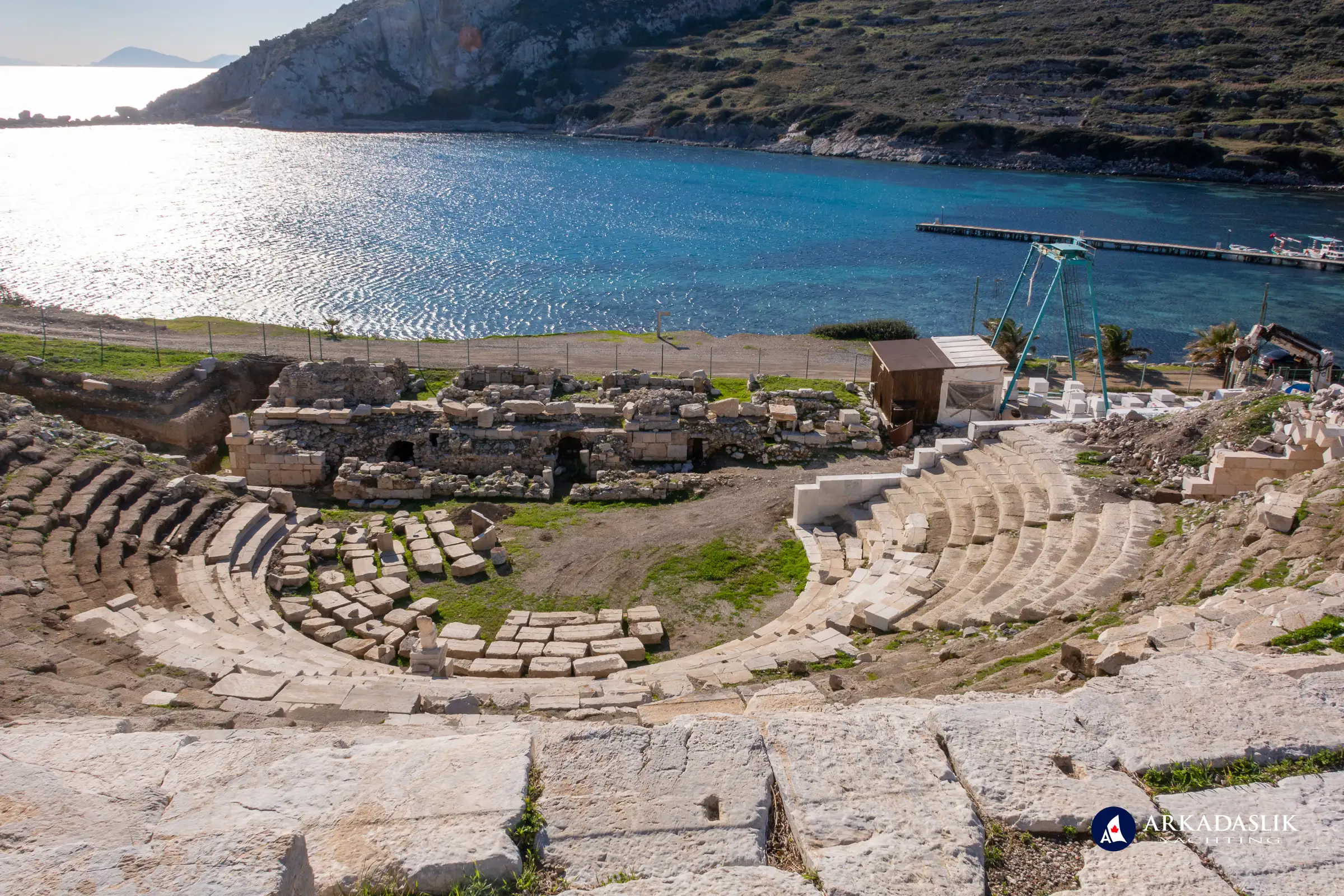
Knidos occupies a breathtaking position, surrounded by two natural harbors formed by the mainland and Cape Krio, a small adjacent island. This dual-harbor setup made Knidos a thriving maritime hub, connecting the Carian coast with nearby Greek islands such as Kos, Nisyros, Tilos, Rhodes, and Symi. The city’s location also allowed for robust trade in olive oil, wine, and ceramics.
Architectural Mastery
Unlike many ancient cities that adapted to the natural landscape, Knidos was meticulously planned on a grid system, with terraces carved into the hillsides. The design reflects an advanced understanding of urban planning, and remnants of its grandeur remain evident today.
Visitors can explore:
- Theatre Complexes
- The small theater, overlooking the commercial harbor, seated 4,500–5,000 spectators and offers stunning sea views.
- The large theater, one of the largest in the ancient world, accommodated an estimated 20,000 people.
- The Agora (Marketplace) – Once bustling with merchants, this central space was the heart of public life.
- Temples of Knidos
- The Temple of Aphrodite was the city’s crown jewel. Its central statue of the goddess, crafted by Praxiteles in 365 BC, was groundbreaking as the first nude depiction of Aphrodite. This bold artistic choice attracted pilgrims from across the ancient world.
- The Temple of Dionysus, celebrating the god of wine, highlights Knidos’s connection to viticulture.
- The Temple of the Muses, honoring the deities of creativity and inspiration.
Scientific and Artistic Legacy
Knidos was also a hub for intellectual and artistic innovation:
- Eudoxus of Knidos, a renowned astronomer and mathematician, advanced the use of sundials, making significant contributions to the measurement of time. The Knidos Sundial, one of the earliest known in history, was a pivotal development in timekeeping, reflecting the city's advanced scientific knowledge.
- The city was a center for sculpture, with its art influencing other regions of the ancient world.
Mosaics, Necropolis, and Everyday Life
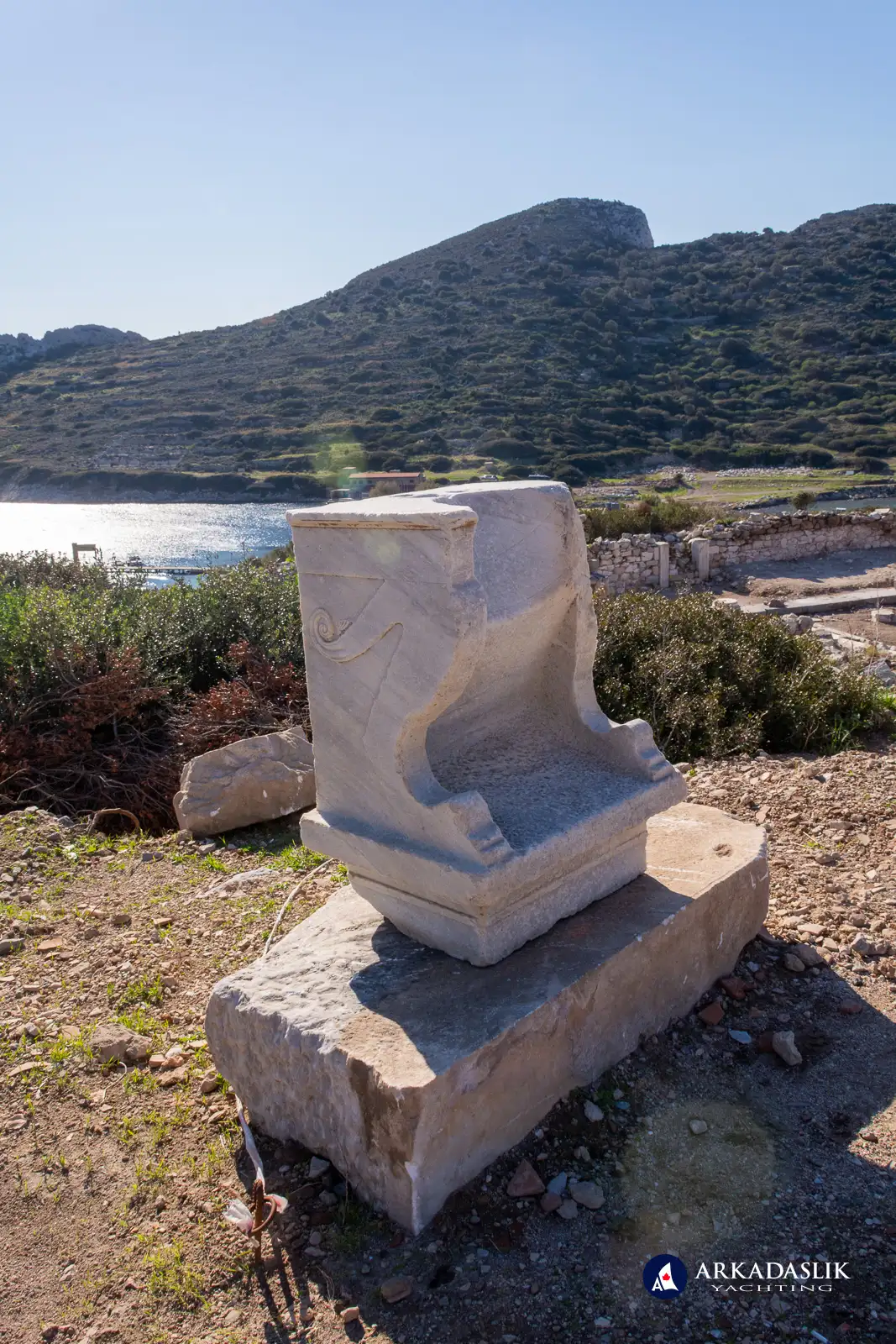
Wandering the ruins, visitors encounter colorful stone mosaics, remnants of early Christian churches, and an extensive necropolis featuring elaborately designed tombs. These reflect the city’s cultural and religious diversity over its long history.
Visiting Knidos Today
Knidos spans 80 hectares and is surrounded by 4 kilometers of ancient walls. While much of the site remains unexcavated, it offers a rare opportunity to step into a city that shaped history. The entrance fee is 5 Euros in 2024, payable in Turkish Lira, making it an accessible experience for travelers.
Knidos can be reached by land or sea, with many choosing to arrive by yacht to enjoy the serene beauty of its harbors.
Knidos: The Ancient Wonder of the Datça Peninsula
Step back in time with images of Knidos’s breathtaking ruins, from grand theaters to intricate mosaics. See its dual harbors, iconic Temple of Aphrodite, and the remnants of one of the ancient world’s most fascinating cities.
Click on any image to expand.


Other Datça Peninsula Highlights
Datça Town
Datça, the peninsula’s main town, lies about 70 kilometers from Marmaris. Its relaxed atmosphere and authentic charm make it a favorite among travelers. The harbor is home to cozy restaurants and bars frequented by locals and tourists alike. Visitors can also enjoy the nearby Ilica Lake, known for its clear waters and small waterfall.
Datça Town: Authentic Charm by the Aegean
Explore the relaxed beauty of Datça town through stunning photos of its cozy harbor, spring-fed Ilica Lake, and vibrant streets. See why this authentic Turkish town continues to enchant locals and travelers alike.
Click on any image to expand.


Palamut Bükü
With its 2-kilometer stretch of pristine beach, Palamut Bükü offers some of the cleanest waters in the region. The inland village retains its historical charm, once strategically positioned to protect against pirate invasions.
Palamutbükü: Pristine Beaches and Crystal Waters
Discover Palamutbükü’s natural allure with its sparkling waters AND incredible underwater visibility. Perfect for beach lovers and adventurers alike.
Click on any image to expand.


The Datça Peninsula and Knidos are more than just destinations; they are experiences that blend history, nature, and tranquility. Whether you’re exploring Knidos’s awe-inspiring ruins, walking the Carian Trail, or relaxing on Palamut Bükü’s beach, the peninsula offers something extraordinary.
Plan your visit now to uncover the stories of Knidos and the serene beauty of the Datça Peninsula.