
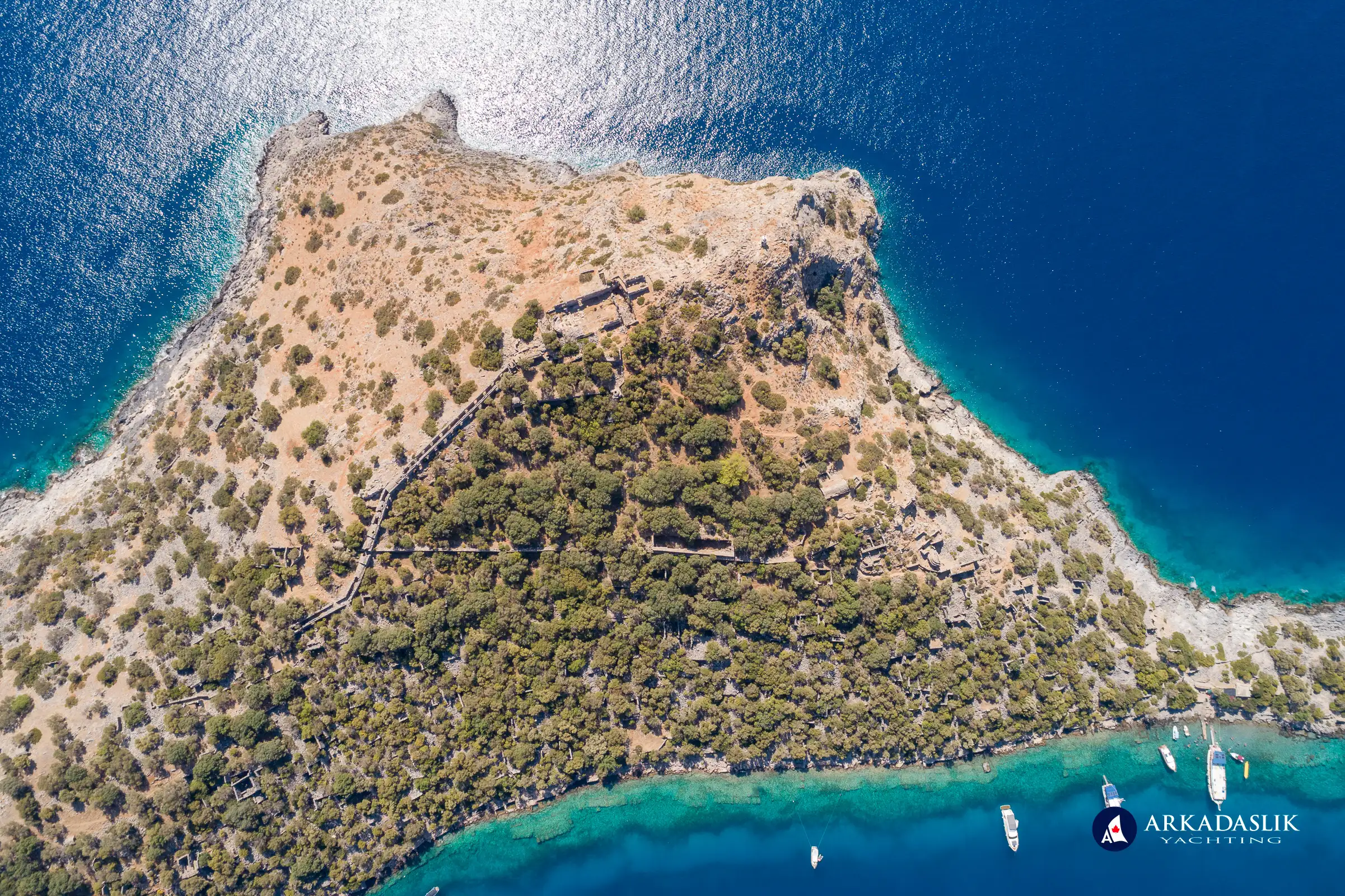
Located just off the coast of Turkey near Fethiye, Gemiler Island is a peaceful Mediterranean retreat rich in history, ancient ruins, and natural beauty. Once home to Byzantine communities and possibly the tomb of St. Nicholas, this uninhabited island offers a unique window into the past. Visitors can explore ancient churches, hike scenic trails, or enjoy the stunning Mediterranean views. Gemiler Island is an essential stop for those interested in history and the natural environment.
The island is surrounded by mainland on three sides, which means it is well-protected during bad weather. Boats anchored in the channel on island's north shore remain safe, even during the worst of storms.
A few scattered islets lay to the south of the island. Although these rocky outcroppings are not mentioned on most maps or articles about St. Nicholas Island, they are home to the ruins of stone structures that (we assume) were once part of the Gemiler Island settlement.
Gemiler Island is currently uninhabited – except by a big orange tom cat (who frequently accompanies hikers around the island), several goats, a few lizards, and a small army of mosquitos! Pine, olive, and carob trees grow everywhere. There are a few walking paths around the island, but they are covered in loose scree, so visitors who want to spend any time exploring should wear good walking shoes (and plenty of insect repellent).
Saint Nicholas and the Island's Sacred History
So what's the connection to Saint Nicholas? There are actually two:
- The first is that the island is believed to have been the original location of the tomb of St. Nicholas of Myra, which is supported by the fact that at least one of the churches contains paintings of his likeness.
- Recognizing this historic connection, modern-day visitors have nicknamed the island Saint Nicholas Island or Santa Claus Island.
Either way, it is a well-accepted fact that St. Nicholas lived in the region, so an island named in his honour is not really a surprise.
The History of Gemiler Island
So why did people establish a large community on an island with no available water or tillable soil? Evidence suggests that early Christians fled to Gemiler Island to hide from persecution by the Romans. Once there, they elected to stay and eventually built the island into a prosperous Byzantine community serving the needs of passing ships. In the 7th century, a series of Arab invasions forced the inhabitants to flee, and Gemiler has been uninhabited ever since.
Archaeologists have been able to piece together a fair bit of information about the island's original inhabitants based on the weather-beaten ruins that dot the landscape. While there were no public buildings, theatres or bath houses as are commonly seen in other settlements, there were four churches spread across the west end of the island, and a crowded community of houses on the north end adjacent to the harbour. There are also several large fresh-water cisterns on the island, indicating the island's inhabitants had effective mechanisms for collecting rain water.
Unveiling the Ruins: A Journey Through Time
The Harbour
There was an extensive harbour along most of Gemiler Island's north side. Buildings and passage ways used to serve visiting boats can still be seen along the steep shore, although some foundations and walls are now underwater due to the effects of earthquakes and rising sea levels.
In the past, visiting boats would anchor in the narrow channel to replenish their supplies of olive oil, fresh water, and whatever else they needed on their journeys across the Mediterranean. Nowadays, boats anchor in those exact same spots, tying their lines to the remains of stone quays that have held boats securely for over a thousand years! (The main difference is that the island is no longer a source of provisions. Instead, we rely on visits from the Pancake Lady and Ice Cream Man to make our journeys more enjoyable ;-).)
The Churches of Gemiler Island
The ruins of four churches can be found on Gemiler Island. (Some sources indicate there was a fifth church on the island, but we cannot find reliable documentation – and we've only found 4 during our (admittedly-uneducated) wanders around the island.) The churches, all built in the late 5th and early 6th centuries, were central to the Orthodox Christian community.
Church 1
If you access the island through the official entrance gate, you'll come across the ruins of Church I after just a short hike. This small stone church was the first built on the island, and all that remains is the south-facing wall of the apse and baptistery.
Church 2
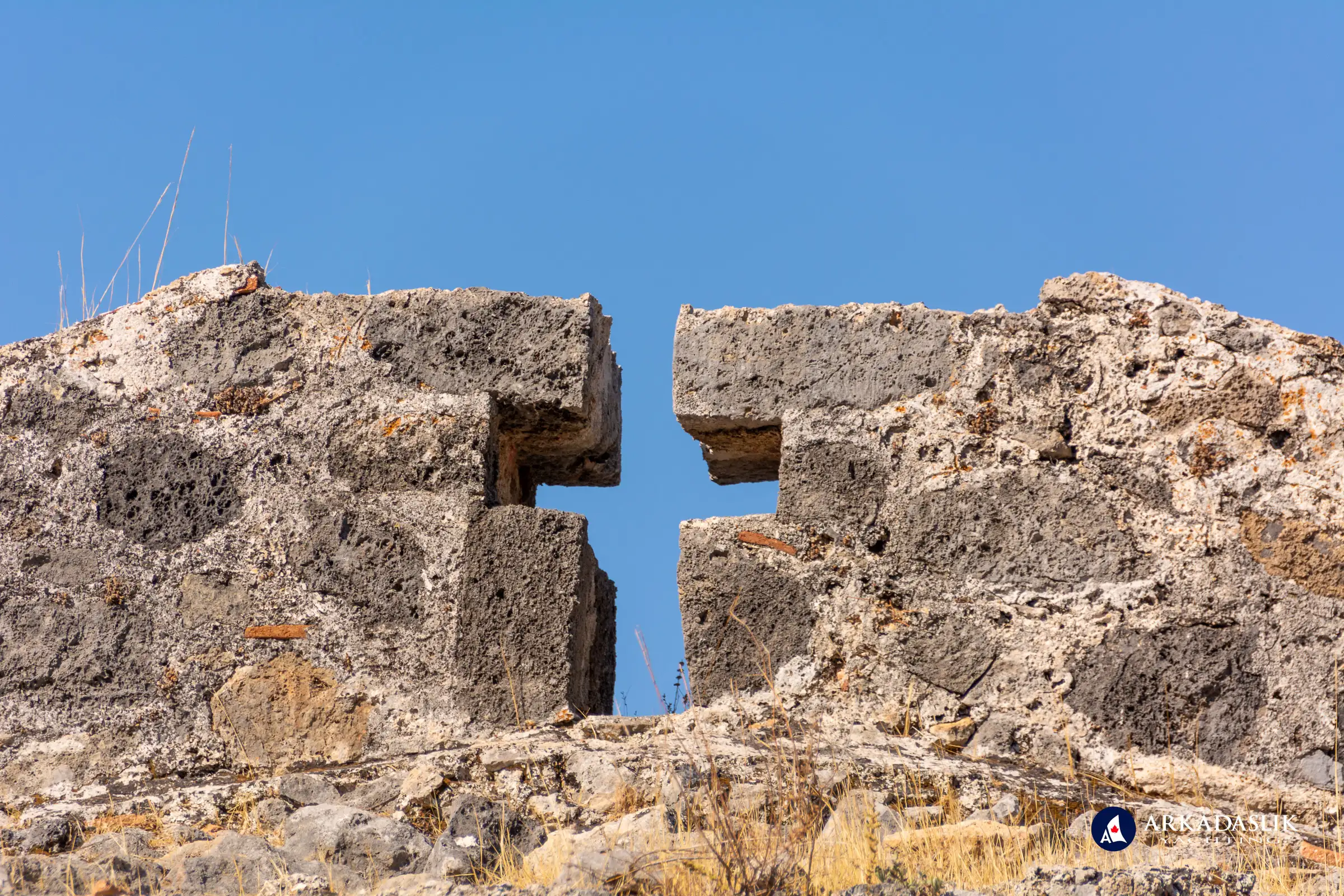
Continue your climb and you'll arrive at the more-extensive ruins of Church II. Featuring a curved wall and semi-domed roof with the shape of a cross cut-out from its peak, this is likely one of the most photographed spots on the island.
Unfortunately, in their haste for the perfect Instagram selfie, most visitors fail to notice the faded frescoes of St. Nicholas and other religious icons around the north door when entering Church II. (In all honesty, the paintings are in a shaded area and difficult to see.) Although these depictions have been defaced – quite literally, the faces have been destroyed – they have survived the ravages of time because they are in a short length of relatively intact, enclosed hallway.
Church 3
Viewing the remains of the most impressive church built on the island requires a climb to its peak. Only a few walls remain of this church, which was partially built into the bedrock of the island. However, the semi-circular apse has been reconstructed by archaeologists and parts of the incredible mosaic floor remain intact.
Some archaeologists believe that this church is where the earthly remains of St. Nicholas were originally entombed after his death in 326 AD, and remained until around 650 AD when they were relocated to the church in Myra for safekeeping during Muslim invasions.
While little remains of the structure now, its distinctive outline at the peak of the triangular island was mentioned in marine charts of the time, helping sailors navigate their Mediterranean journeys.
Church 4
The remains of the final church on Gemiler Island are practically non-existent, just a small section of mosaic floor on the east side of the island. Little is known about this church, but it must be assumed that it was integral to funeral proceedings due to its location adjacent to the island's extensive cemetery.
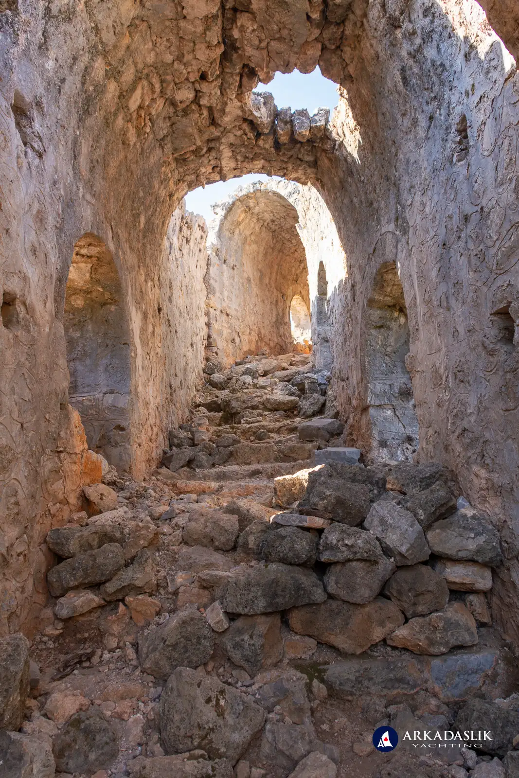
The Corridor
A 350 meter long, arched stone corridor joined churches 3 and 4. Enclosing a long stairway, the processional walkway featured 14 stops (representing the Stations of the Cross) where priests would pause to pray when moving back and forth between the buildings.
Although much of the ancient passageway has collapsed, parts of the structure remain standing – including sections of the arched roof! Decorations in the mortar and stone work are still visible too, evidence of the craftsmanship of the builders.
The Cisterns
Two massive stone cisterns were used to collect and store rain-water on the island. One was located on the eastern peak of the island, the other on the hill above the harbour. It is likely that the water in this second cistern was sold to passing boats in need of fresh water for their journeys, while the water in the first was used by the island's inhabitants.
The Wall
A long stone wall separated the secular part of the island from the area where the churches were located. Amazingly, much of the wall is still standing and can easily be seen in aerial photos of the island.
The Graveyard
The east half of the island is devoted to an extensive cemetery housing over 50 tombs and graves.
The Religious Importance of St. Nicholas Island
Due to its connections to St. Nicholas of Myra, Gemiler Island has long-held religious importance. It is believed that the island was a frequent stop on the pilgrimage route from Constantinople (now known as Istanbul) and countries in the west to Jerusalem and other religious sites in the eastern Mediterranean.
Modern Day Gemiler Island
Gemiler Island is managed by the Turkish Ministry of Culture and Tourism. An entry fee of 3 Euro (2024 price, payable in Turkish Lira at the day's prevailing rate) is charged to access to the island, but, because it is part of the national museum system, you can also use your Muze Kart.
How to Get There: Your Gateway to Gemiler Island
Boats of every size and shape frequent the island throughout the year. In fact, it's not uncommon to see small sailboats anchored next to super yachts! But if you don't have access to a boat of your own, here are some ways to visit Gemiler Island:
- If you can make your way to Gemiler Beach on the mainland, accessing the island is fairly easy. For a negotiated fee, a local "putt-putt" boat will shuttle you the 100 meters across the channel, or you can make your way under your own power – swim, kayak, paddle board, etc. (If you choose to take matters into your own hands, please be careful around the water sport boats that speed through the channel.)
- Daily boats from Ölüdeniz make the trip every day during the summer. The down-side to these trips is that they only visit the island for about 45 minutes before heading to the next destination on their route, so you'll need to find a different option if you want more time to explore.
- Private boats / water taxis can be hired for the day from Ölüdeniz beach to shuttle you to Gemiler Island, wait while you explore the island, and shuttle you back to your starting point.
- Virtually every gulet cruise travelling between Göcek / Fethiye and points further east (Kalkan, Kaş, Kekova region, etc.) overnight at Gemiler Island, providing plenty of time to explore the island at your leisure.
The Best Time to Visit
Gemiler Island is accessible throughout the year. Obviously, it is most popular during the summer months, but there is something magic about walking around the island in the winter, when no-one else is around.
During the height of tourist season, the parts of the island nearest to the entrance kiosk are congested during the day, especially when the daily boats arrive and disgorge their passengers. And the area around the lighthouse at the island's peak is busy at sundown because everyone enjoys the view of the sun setting over the Mediterranean. But, even on the busiest days, the rest of the island is virtually empty.
If you are interested in exploring the ruins on the island, the best time to visit is early in the morning before the daily boat trips arrive, or late afternoon, after the bulk of day-time visitors have left, but before the masses head to the peak for sunset viewing. In addition to having the island to yourself at these times, you may find that the entrance kiosk is un-staffed, allowing you "free" access.
The Future of Gemiler Island
Because the island is classified as Protected Land by the Turkish government, construction on Gemiler Island is not permitted. This means that visitors can continue to enjoy its unspoilt beauty while trying to unravel its mysteries.
Explore Gemiler Island Through Our Lens
Gemiler Island, often referred to as St. Nicholas Island, is a place where history and nature seamlessly blend. Our curated photo gallery invites you to explore its ancient Byzantine churches, serene landscapes, and timeless ruins. The images capture the spirit of the island — from the remains of the churches where early Christians once gathered to the striking views of the Mediterranean and surrounding islets. Whether you're planning a visit to this tranquil destination or simply intrigued by its fascinating history, our gallery offers a visual journey into the heart of Gemiler Island.
Click on any image to expand.


Whether you're a history buff, a hiker, or simply someone looking to escape the crowds, Gemiler Island offers a unique, peaceful experience. Plan your visit today and uncover the secrets of this Mediterranean gem.